The National archives in the UK provide access to a collection of historical maps (Archives, n.d.). In this archive, maps concerning the exploration of the West Indies and, in particular, Antigua have been incorporated with details of the geology and structure of the island (Warneford, 1949). As an Antiguan citizen who lives in England, I find the history of the British colonies in the West Indies and related islands very interesting.
Firstly, the 1775 survey map by Robert Baker (1775) is referenced by Waters (2019), noting that the original survey was produced as a 56” x 45” map, which was subsequently engraved in copper to be printed and published. This document captured the geographic features, including plantations, harbours, roads, churches, gun batteries, and windmills, that formed the economic and military basis of the island. This work by Baker was initially produced in a series of surveys made between 1746 and 1748, but was only published in 1775.
The map (fig.1) contains a detailed cross-section of the island and a detailed map of English harbour. This map documented the seagrass and reef locations so that those engaged in shipping could navigate the island safely. Unfortunately, as Barber (2011) contends, only limited manuscripts and maps survive documenting this region. Research into the early sugar trade, slavery and the positioning of naval supply ports within the 18th century requires analyzing these documents. As Sheridan (1977, p. 255), earlier versions of the map by Baker captured information concerning sugar plantations and formed historical markers that are now used in analyzing the changes to the island and the role of the West Indies in supplying the British Navy during the colonial revolution.

Figure 1: Survey map of Antigua (1775)
Related maps can be sourced from the York institutional repository (Found, 2011). Following the passing of a law in England in 1675 concerning establishing six trade towns in Antigua, it was necessary to map the island so that the sugar industry and the naval fortifications could be adequately maintained (Bord, 2019). Additionally, the British ordinance survey contains more recent and older historical maps and survey archives (Historical Map Archives, n.d.). As a comparison, a map by the “Great Britain: Directorate of Overseas Surveys, (1947)” produced at a 1:25,000 scale of Antigua island delivers a new litho contour map which is coloured and measures 36” x 49.25” and shows the states, mills, towns, reefs and shoals with multiple roads and footpaths (Fig. 2a, 2b).

Figure 2a: Survey map of Antigua (1947) - West

Figure 2b: Survey map of Antigua (1947) - East
Comparing the earlier and later maps shows the increasing level of detail available with the introduction of new technologies. While this still demonstrates far less resolution than is available today with Google maps, capturing information in the 1940s and 1950s using traditional surveying techniques demonstrates the level of depth that can be achieved even with manual technology. The Directorate of Overseas Surveys map of Antigua was initially released in 1947 with photographic overlays used to improve the map and to revise the roads in 1958 and then in 1959. As a result, the level of detail is far higher, with the full 1959 map taking 445 MB.
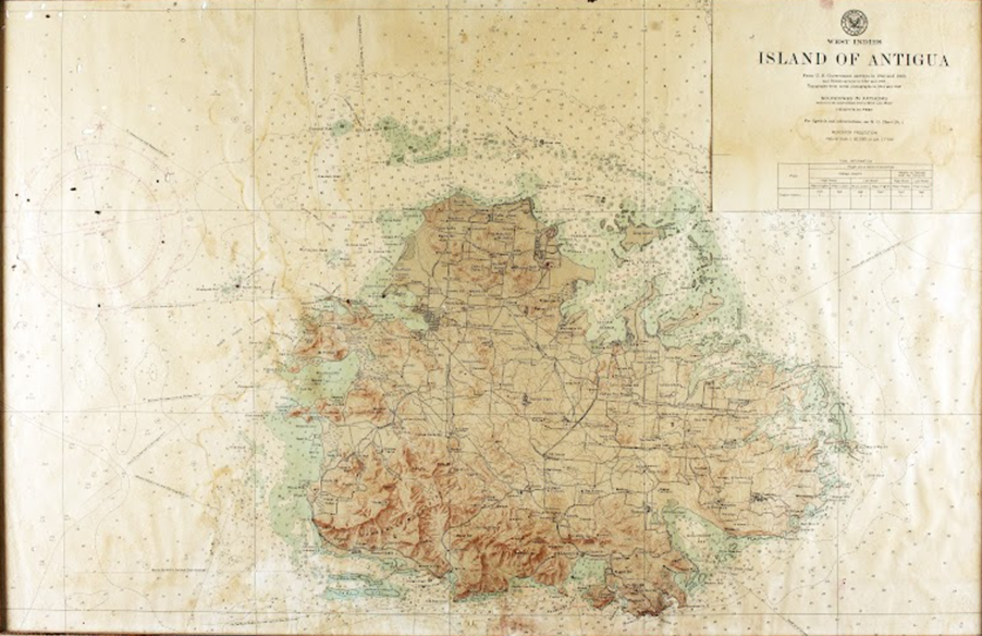
This British map can be compared with the 1943 US Army map developed to aid regional naval shipping during World War II. The changing political influences are partly represented in the level of detail captured within the map. Initially, mapping was not available to the United States Navy as this was English territory, but as World War II continued, the requirement for documenting information surrounding the United States grew in importance.

Figure 3: US Army (1943) Island of Antigua
While the British survey map (Fig 2a, 2b) captures the land and the terrain of the island, the United States Naval and army mapping focused more on topography, including mountains and the surrounding oceanic features. In particular, the US Army (1943) map focuses on landing ports on the island and naval facilities. With the ability to photograph the island, the impact of technology significantly changed the level of detail available. The addition of only 15 years shows how significantly different the mapping techniques became between the 1940s and 1950s.
References
Archives, T. N. (n.d.). The National Archives—Homepage [Text]. The National Archives. Retrieved 3 April 2023, from https://www.nationalarchives.gov.uk/help-with-your-research/research-guides/maps-further-research/
Barber, S. (2011). ‘Not worth one Groat’: The Status, Gentility and Credit of Lawrence and Sarah Crabb of Antigua. Journal of Early American History, 1(1), 26–61. https://doi.org/10.1163/187707011X556886
Bord, A. J. K. (2019). Crossroads on the Coast: A Preliminary Examination of Bridgetown, Antigua [Thesis]. https://oaktrust.library.tamu.edu/handle/1969.1/184252
Found, W. C. (2011). A research collection of historical maps and prints of the Caribbean Islands. Part 1: Photographic prints, photocopies and facsimiles. https://yorkspace.library.yorku.ca/xmlui/handle/10315/13674
Historical map archives. (n.d.). Retrieved 3 April 2023, from https://www.ordnancesurvey.co.uk/about/history/historical-map-archives
Sheridan, R. B. (1977). The West Indian Antecedents of Josiah Martin, Last Royal Governor of North Carolina. The North Carolina Historical Review, 54(3), 253–270.
Warneford, F. H. S. (1949). An introduction to the geology of Antigua.
Waters, C. K. (2019). Indefensible Landscapes. Power, Political Economy, and Historical Landscapes of the Modern World: Interdisciplinary Perspectives, 153.

